4D-WORKS Guide: Towards Automatic Metadata Curation for 4D Topographic Observation
4D topographic data, i.e. dense 3D time series, have become increasingly available through near-continuous in-situ observation using, e.g., laser scanning or photogrammetry, to capture Earth surface dynamics across time (Lindenbergh et al., 20253). Unlike traditional multitemporal datasets with only a few repeat point cloud acquisitions, the time series consist of a high number of epochs (typically hundreds to thousands; e.g., Vos et al. 20211, Anders et al. 20222) and create a great challenge for consistent metadata handling due to a lack of established practices regarding time-dependent metadata. Essential processing information and products, such as transformation matrices required for time-dependent alignment of epochs, has not yet been handled in a consistent manner and usually provided as supplementary files in formats tailored to the user-specific tools that were used for the processing. Reusing the data in different workflows and domains can thus be tedious, as they often require customized scripts to read the large volumes of 4D (3D+time) data. Especially with emerging efforts of research groups to publish such valuable datasets, the development of uniform and flexible metadata practices is a timely effort to establish a cross-community practice.
The aim of our 4D-WORKS metadata practice is to improve interoperability, simplify reuse across Research Data Management (RDM) workflows by the Earth System Science (ESS) community, and encourage increasing 4D dataset publication by reducing preparation effort. To address this, we propose a metadata schema and automated curation workflow tailored to time-dependent topographic datasets, implemented as a dedicated Topographic 4D (topo4d) extension of the SpatioTemporal Asset Catalog (STAC). The extension formalizes how time-dependent metadata (e.g., epoch-wise transformations, acquisition parameters, and derived products) can be structured, validated, and shared in a machine-readable and interoperable way.
While early developments in 4D topographic monitoring have largely focused on terrestrial laser scanning (TLS), similar challenges arise across a broader range of observation techniques. Photogrammetric time series derived from UAV or ground-based imagery increasingly provide dense multi-temporal surface reconstructions, while satellite-based elevation products (e.g., stereo imagery, InSAR, or multi-spectral imagery) contribute to large-scale spatiotemporal Earth monitoring. Across all these data, consistent handling of time-dependent metadata, such as acquisition details, processing parameters, and epoch-wise transformations, remains a common challenge. The 4D-WORKS approach is therefore designed to be sensor-agnostic, supporting multi-source datasets and enabling integration of heterogeneous time series within a unified metadata framework.
Guide Overview
This documentation summarises how to ingest, construct, and search a STAC-based metadata framework using the topo4d extension for topographic 3D time series data. It consists of the following components:
- Guide outlines the metadata ingestion, construction, and usage workflow.
- Topo4D Extension API provides the STAC extension fields and validation helpers.
- Builder API provides helpers for making STAC Items using other community open-source tools, e.g., laspy, PDAL, etc.
- Notebook: make_STAC_kijkduin is an example notebook building a STAC catalog from near-continuous terrestrial laser scanning point clouds.
- Notebook: make_STAC_Isar is an example notebook building a STAC catalog from multi-temporal multi-source in-situ point clouds, including relevant change analysis products.
- Notebook: demo_stac_kijkduin is an example notebook showcasing the usage of STAC catalog with change analysis tools, here, py4dgeo.
Introduction
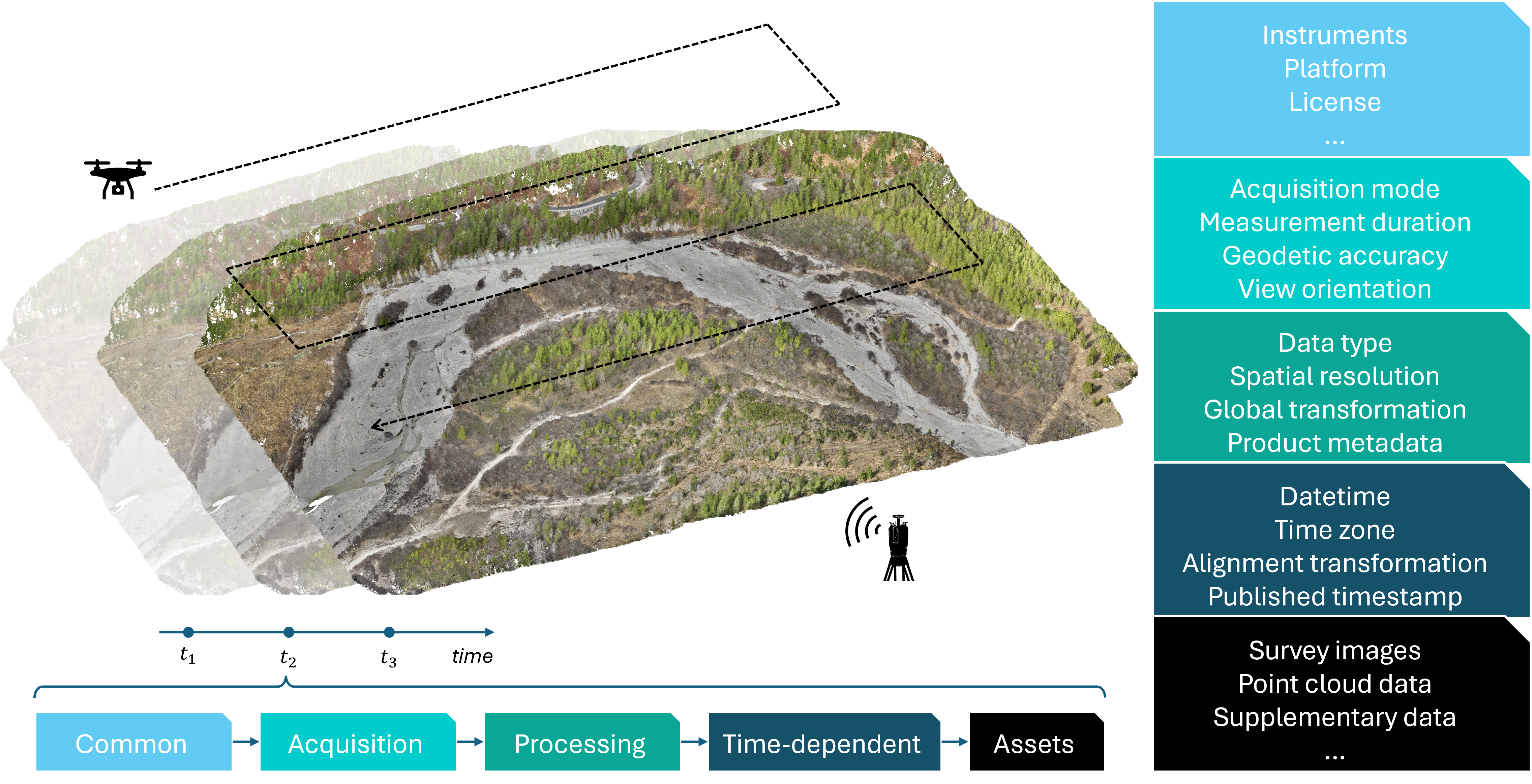 Different types of metadata (Common - Acquisition - Processing - Time-dependent - Assets) generated during the classical topographic change analysis workflow. (Figure by Wang et al.4).
Topographic 4D data provide dense 3D time series that capture surface change across many epochs. These datasets are valuable for understanding natural processes, infrastructure monitoring, or hazard assessment. However, their reuse and publication are often limited by heterogeneous or incomplete metadata.
Metadata describes the who, what, when, where, why, and how of a geographic dataset, thus ensuring that others can understand, reproduce, and integrate the datasets. As shown in the figure above, metadata in 4D topographic observations can be grouped into five categories4:
-
Common metadata: General information such as instruments, platforms, or licenses. Example: sensor type (e.g., UAV with RGB camera) or data license (e.g., Creative Commons).
-
Acquisition metadata: Details of how the data were acquired, including acquisition mode, duration, positional accuracy, or view orientation. Example: RTK GNSS accuracy in centimeters, flight path of an oblique UAV survey.
-
Processing metadata: Information on data handling, such as spatial resolution, global transformation, or product description. Example: transformation matrices, point density, or classification scheme.
-
Time dependent metadata: Attributes that change with each epoch, including timestamp, time zone, or alignment transformations. Example: acquisition datetime in UTC or per-epoch alignment files.
-
Assets metadata: Links to the actual data products such as survey images, point clouds, or supplementary data.
Currently, these metadata are stored in diverse formats, often tailored to specific software. Common formats include text files (TXT, CSV), XML or JSON files, specialized geospatial formats (GeoTIFF, LAS/LAZ) and proprietary formats from photogrammetry or laser scanning software. Without a uniform structure, reusing the datasets across workflows requires custom scripts and extensive manual effort.
Establishing a consistent metadata framework is therefore crucial to ensure interoperability and reproducibility as well as lowering the barrier for publishing and reusing datasets, thus increasing their scientific and practical value.
Prerequisites
Before using the Topo4D metadata curation framework, some basic knowledge and tools are required. Users should be familiar with point cloud data formats (e.g., LAS/LAZ), common metadata standards, and the SpatioTemporal Asset Catalog (STAC). A Python environment with the provided toolkit topo4D Extension API, as well as access to representative survey data demo data from laser scanning or photogrammetry, is recommended.
Metadata Curation Workflow
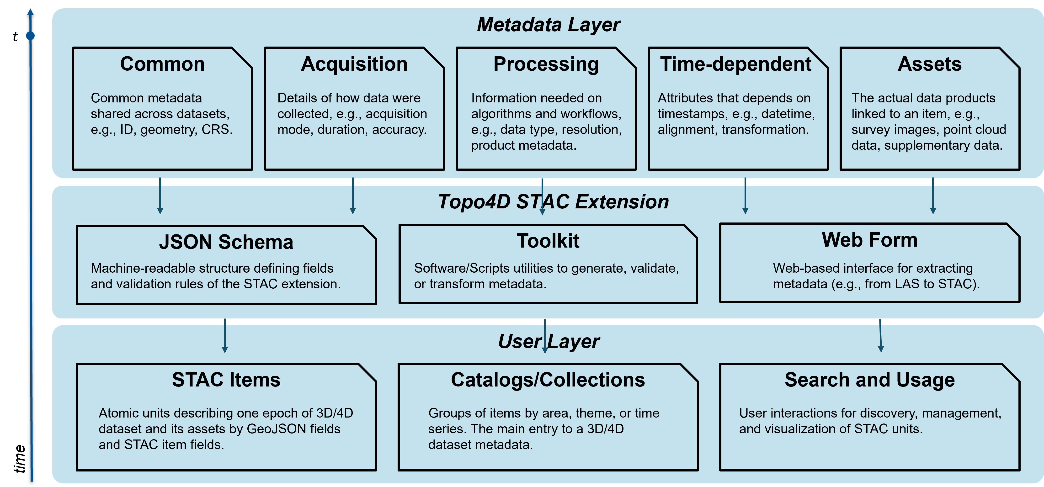 Three-layer architecture of the Topo4D STAC extension for 3D/4D topographic metadata curation. (Figure by Wang et al.4)
Our system for 4D topographic metadata curation is structured into three layers.
-
Metadata Layer: Defines five categories of metadata: common (general dataset information), acquisition (survey details), processing (workflow and algorithms), time dependent (epoch-specific attributes), and assets (linked data products).
-
Topo4D STAC Extension: Provides the technical framework with a JSON schema for machine readability, toolkits for generating and validating metadata, and a web form for extracting metadata directly from raw data such as LAS files.
-
User Layer: Organizes the curated metadata into STAC items and catalogs for 3D and 4D datasets, enabling efficient search, discovery, and reuse across domains.
This architecture ensures metadata are consistent, interoperable, and directly usable by both researchers and applications, lowering the barrier for sharing and reusing 4D datasets.
Next Steps
In practice, users typically interact with this framework through a combination of notebooks and example data. To get started, you can follow the step-by-step notebooks provided in this guide, which demonstrate how to:
- extract metadata from raw datasets,
- construct STAC Items and Collections using the topo4D extension, and
- query and utilize the curated metadata in downstream analysis workflows.
We recommend beginning with the Kijkduin example notebook, which introduces the full pipeline from raw point clouds to a searchable STAC catalog, before exploring more advanced multi-source scenarios such as the Isar example notebook.
References
-
S. Vos, K. Anders, M. Kuschnerus, R. Lindenbergh, B. Höfle, S. Aarninkhof, S. de Vries, "A high-resolution 4D terrestrial laser scan dataset of the Kijkduin beach-dune system, The Netherlands," Sci Data 9, 191, Apr. 2022, https://doi.org/10.1038/s41597-022-01291-9. ↩
-
K. Anders, L. Winiwarter and B. Höfle, "Improving Change Analysis From Near-Continuous 3D Time Series by Considering Full Temporal Information," in IEEE Geoscience and Remote Sensing Letters, vol. 19, pp. 1-5, 2022, Art no. 3511105, https://doi.org/10.1109/LGRS.2022.3148920. ↩
-
Lindenbergh, R., Anders, K., Campos, M., Czerwonka-Schröder, D., Höfle, B., Kuschnerus, M., ... & Vos, S. (2025). Permanent terrestrial laser scanning for near-continuous environmental observations: Systems, methods, challenges and applications. ISPRS Open Journal of Photogrammetry and Remote Sensing, 100094, https://doi.org/10.1016/j.ophoto.2025.100094. ↩
-
J. Wang, X. Huang, P. Maydhisudhiwongs, M. Letard, B. Teuscher, M. Werner, K. Anders, "topo4d: Topographic 4D STAC Extension for Curating and Cataloging Multi-Source Geospatial Time Series Datasets", ISPRS Ann. Photogramm. Remote Sens. Spatial Inf. Sci., XI-2-2026, 545–552, https://doi.org/10.5194/isprs-annals-XI-2-2026-545-2026, 2026. ↩↩↩